

The treasure hunters of The Neale
The treasure hunters of The Neale
The stones are vanishing but the magic is still there

A circle around the Long Stone marked as Standing Stone in red on the map
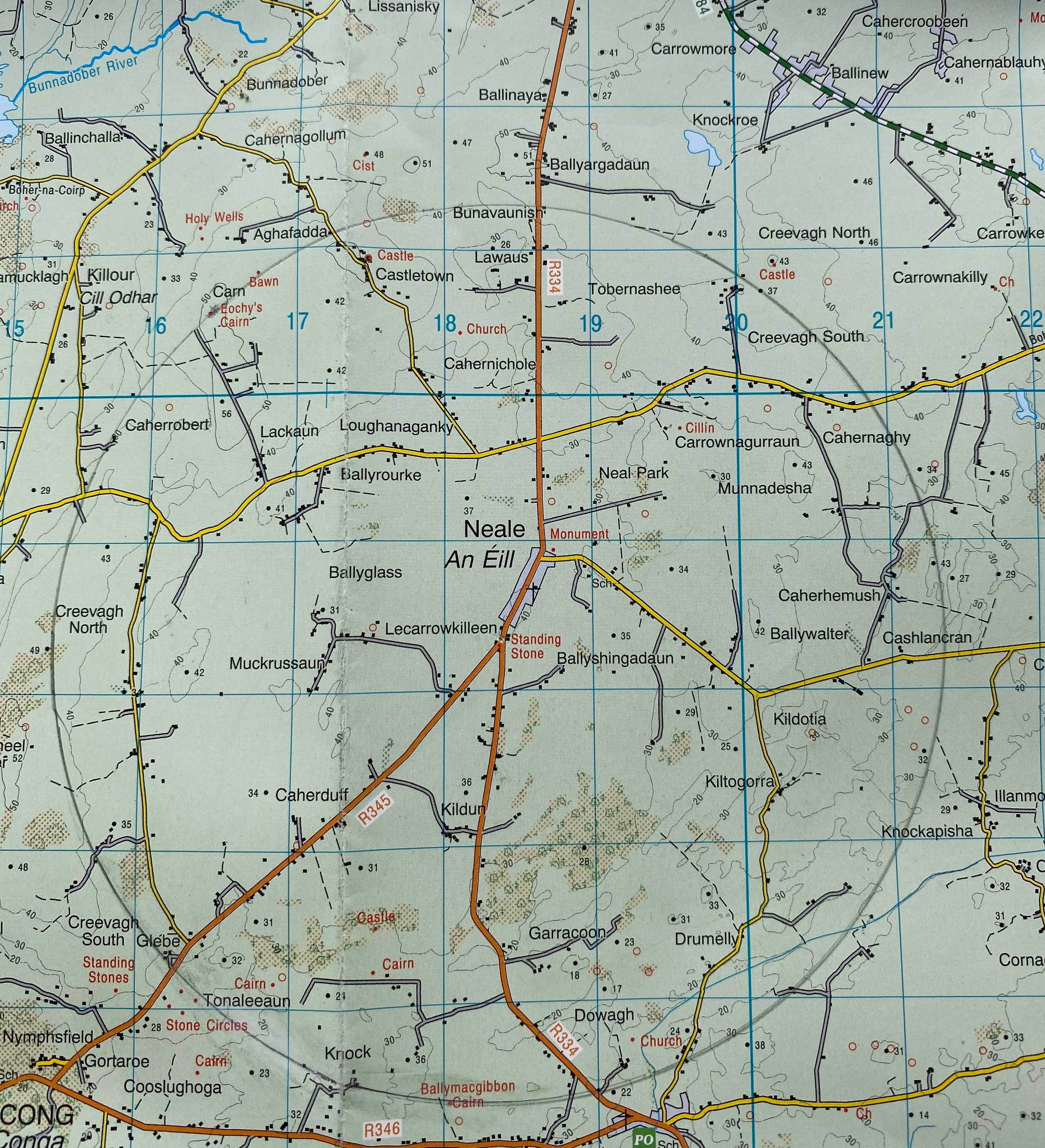
The modern roads leading in and out of the Neale are remarkably straight, running over very old roads. The road to Cong and the Nymphsfield stone circles runs southwest from the Long Stone, which marks the turning, a first clue that there’s something epic going on in this area. Back in Westport, I buy the ordnance survey map for South Mayo, and a maths set with a compass and some rulers, and draw a circle around the Long Stone, starting at the Nymphsfield circles. I notice it passes through Ballymacgibbon Cairn to the south, and back through Eochy’s Cairn to the northwest. Inside this circle are hundreds of ancient sites, many untouched for thousands of years. From the Long Stone, the arc between the stone circles and the cairn maps out the path of the sunset from midwinter to the southwest up to midsummer to the northwest. The people who built these circles and cairns and planted the stones made art with light, with the year of sky as their palette.

The Glebe north circle
The Nymphsfield stone circles are three kilometres from the Long Stone, in the fields off to the left, and one circle known as the Glebe North circle is visible from the road. In fine weather, there’s often artists sitting sketching under the big trees surrounding the stone circle. Across the road from the circles, a standing stone marks the point of the midwinter sunset from the Long Stone.
Much of this area was plundered going back several hundred years. The stone circles lay for many years inside the Glebe, the land of the serving local priest or parson of the Church of Ireland. When Wilde met the parson in the late 1800s, the parson informed him that the Glebe house was built on top of a great stone fort that once stood there. At the Glebe and the north end of town are sites reputed to hold great treasures. As far back as the 1500s, the Knights of the Order of St John of Jerusalem held land close to Ballinrobe, the next town above the Neale. The military order, also known as the Knights of Malta, still in operation to this day, were treasure hunters and robbers, the original pirates with the skull and bones as their secret motif. In their wake came other orders including the freemasons. Later followed explorers and scientists sponsored by royal academies and museums who wrote and published their accounts as part of the mapping of Ireland for colonial purposes.
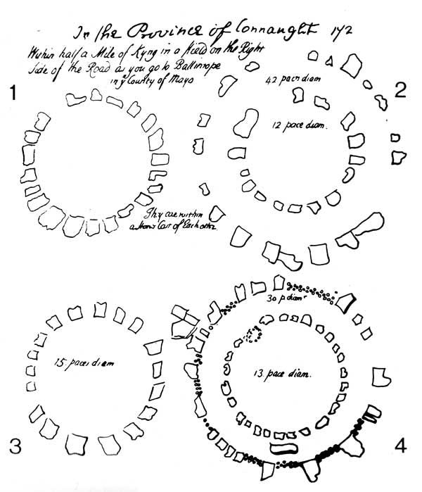
Edward Lwhyd’s 1699 sketch of the circles. A pace is about two and a half feet.
One of the earliest accounts of these stones comes from the Welsh writer Edward Lwhyd who sketched the circles in 1699. From his sketch (above) it’s clear there are far fewer stones now. Lwhyd recorded double rows of stones, little sense of which remains. One single circle remains complete, with its outer stones built into the surrounding wall in the great Irish tradition of using a monument as the centrepiece of your back garden. The Glebe north circle stands on a hill surrounded by a railing and trees, while the great circle alone in its field is a shadow of its former self.
Stone circles aren’t unique to Ireland, and their purpose is still little appreciated. This grouping of circles is very unusual though. These circles don’t reward a flying visit well. They are places that require one to linger, but they don’t exactly invite it either. There are subtle interactions between the stones and the underground watercourses that change by day and night. You might notice that the Glebe north circle has some long stones lying sideways at opposite points. You may also notice that the stone circles are each in their own field, and that the four circles are in three different townlands: Glebe, Toneleeaun, and Nymphsfield. But it will be a personal experience as these places really offer mystery and questions more than answers, if you can live with that sort of thing.
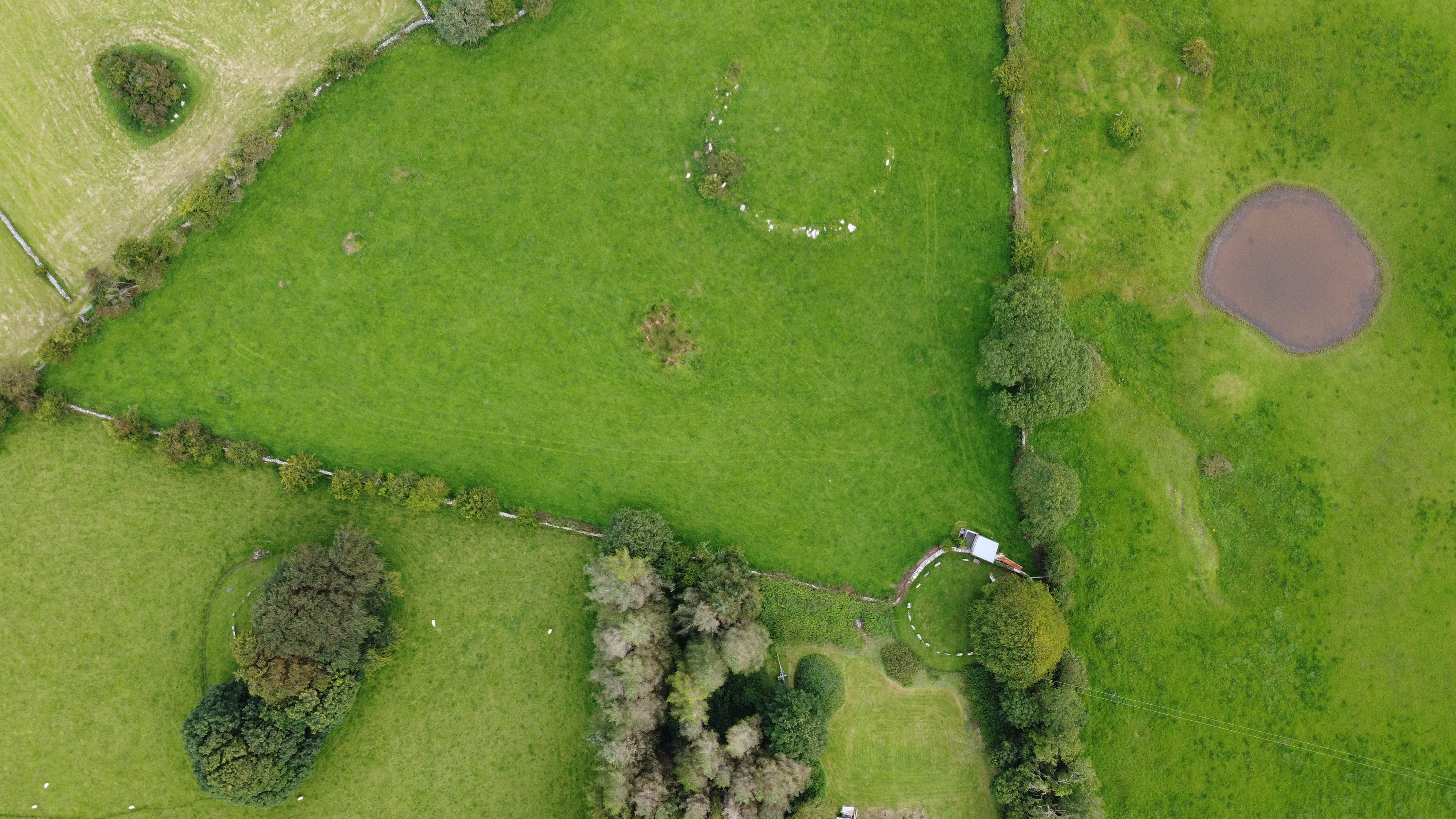
The Toneleeaun, Glebe and Nymphsfield stone circles
The legends of this area are recorded as the Battle of Moytura in the Book of Invasions, and connect the stone circles and Eochy’s Cairn. William Wilde spent much of his life exploring the area in the course of writing some of the first guide books for Galway and Mayo in the mid-1800s, trying to match up the ancient stories with various cairns. With a copy of the Book of Invasions, and its description of the battle of Moytura, Wilde traced one story to a spot he describes as a set of steps leading down to a cave with an underground river, somewhere close to the circles. Here, the legends describe how King Eochaidh of the Fir Bolg was attacked while washing one morning ahead of battle. He later died from his injuries, and the great cairn directly to the north bears his name.
Wilde and the local landlord dug into a cave at the centre of a mound and discovered a structure and an ancient urn, which Wilde handed over to the Royal Antiquaries. No one has found this spot in recent times, and it may have been filled in to stop animals falling into the cave. But the stories of Eochaidh and the underground streams remain fascinating. Rich in caves with underground water, the Neale seems like a place where one could vanish for days or weeks, fleeing an invasion. The stories of the Tuatha de Danann resonates with the theme of a people vanishing underground with their treasures, but leaving their art behind.
For what’s left overground is still more than enough for us to work with.